Stadium Boulevard
From Washtenaw Ave. split to just west of 7th St.

This is the Engage Ann Arbor site for the Ann Arbor Roadway Rightsizing (A2R2) Project.
 The goal of this study is to improve safety, reduce vehicle speeds, and enhance multimodal connectivity along arterial streets. This project will result in conceptual designs for the ten corridors that are responsive to the Moving Together Towards Vision Zero Transportation Plan and A2ZERO plan.
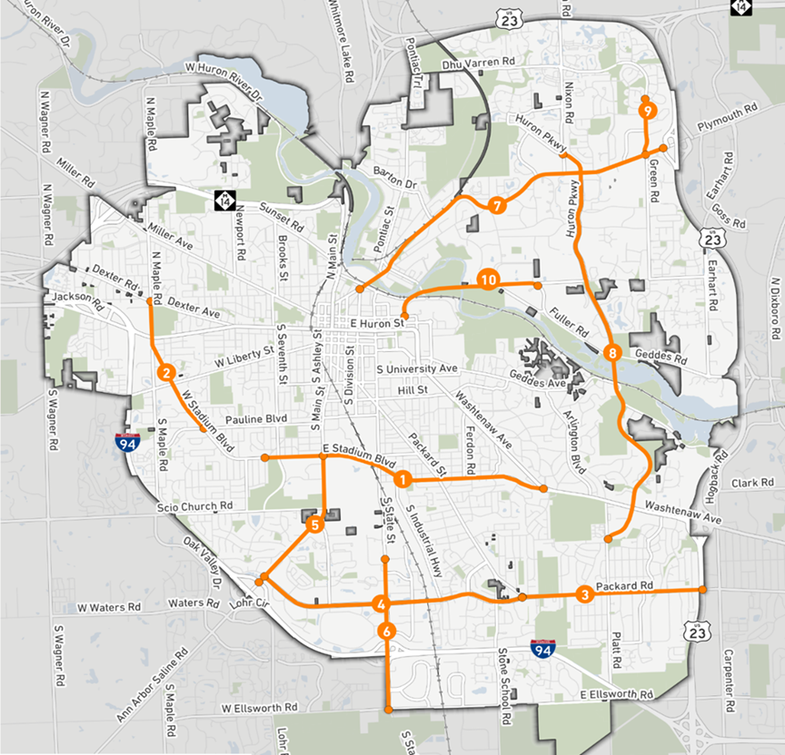
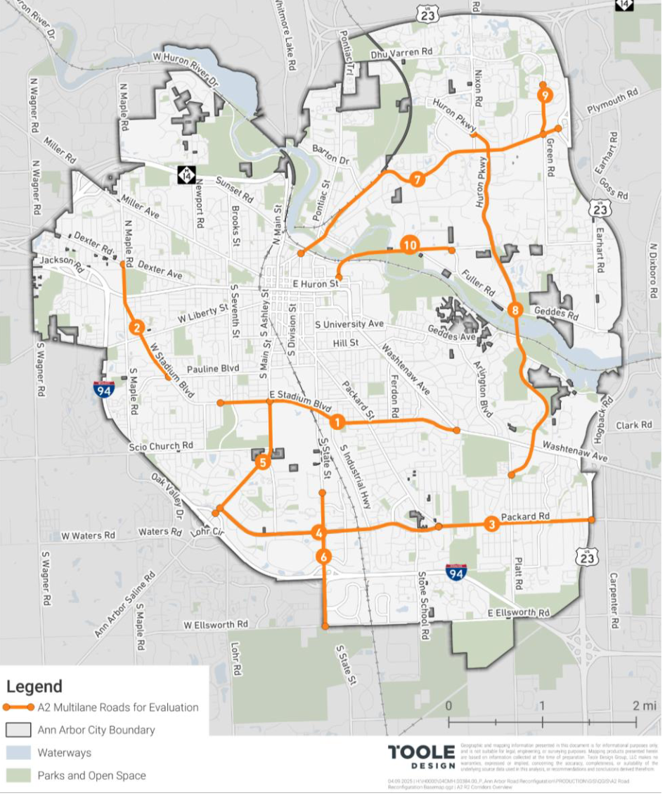
The ten A2R2 Corridors include:
Why is this project being done?
In 2021, the City of Ann Arbor adopted the Moving Together Towards Vision Zero Comprehensive Transportation Plan, which is organized around achieving two big goals:
In pursuit of these goals, the City recognizes that:
The Moving Together Towards Vision Zero Transportation Plan recognizes that a disproportionate number severe crashes occur on higher speed, wide arterial streets and intersections. As a step to direct attention and resources to the high crash severity streets, the City published a Speed Management Program and Toolbox, identifying a set of tools for street designs that produce lowered vehicle speeds and increased driver attention.
The A2R2 aims to improve safety, reduce speeds, and enhance multimodal connectivity along arterial streets. This project purpose is aligned with the broader Moving Together Towards Vision Zero goals through strategies such as redesigned intersections, quick-build treatments, and community engagement.
Work to be done
The Ann Arbor Roadway Rightsizing (A2R2) project will evaluate the feasibility of “rightsizing” arterial streets. Rightsizing refers to re-purposing excess motor vehicle traffic lanes for other uses such as dedicated transit lanes, separated bike lanes, or additional sidewalk and amenity space.
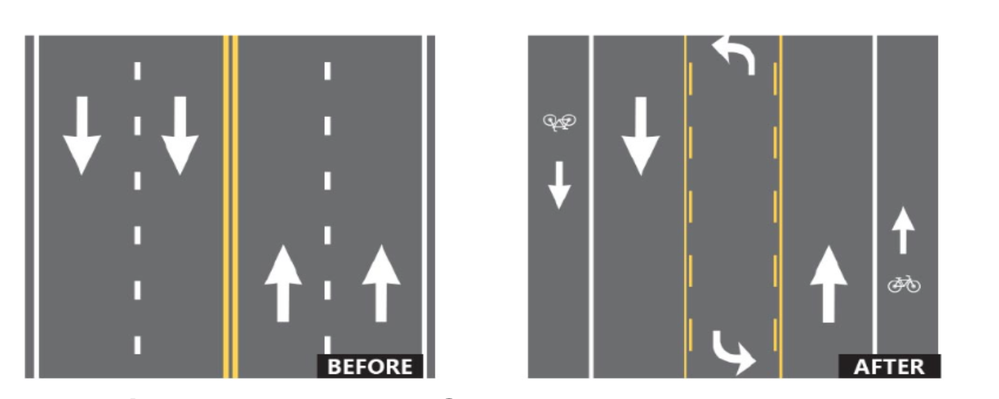
Figure 1: FHWA Proven Countermeasure Diagram
Roadway Rightsizing projects can reduce speeds, better organize traffic, address systemic safety issues, and incorporate planned transit and bicycle infrastructure throughout the City.
This project will result in conceptual designs for the ten corridors that are responsive to the Moving Together Towards Vision Zero and A2ZERO plan.Funding Source
Council-directed use of the city's major streets Act 51 resources.
This project will result in conceptual designs for ten corridors that will apply proven safety countermeasures to improve safety, reduce vehicle speeds, and enhance multimodal connectivity along arterial streets.
The City of Ann Arbor has a long history of Roadway Rightsizing projects including these examples from the last decade:
Phase I Engagement Opportunities
Phase II Engagement Opportunities
Check back soon for more details on how to participate and make your voice heard.
From Washtenaw Ave. split to just west of 7th St.
Just southeast of Pauline Blvd. to Dexter Ave.
Eisenhower Parkway split to US-23
Ann Arbor-Saline Road to Packard St. split
Stadium Blvd. to I-94
Just north of Oakbrook Dr. to Ellsworth Road
US-23 to Division St. / Beakes St. Interchange
Platt St. split to Nixon Road
Plymouth Road to Burbank Dr.
Catherine St. to Glazier Way
![]()
Have questions or want to learn more about a project, contact us below:
| Phone | 734.794.6000 |
|---|---|
| Website | www.a2gov.org |
| In writing | 301 E. Huron St. |


