
This is one year study, performed by the City of Ann Arbor and the Ann Arbor Downtown Development Authority, with Toole Design, will focus on the design and user experiences of North Main Street from Huron Street to West Huron River Drive.
Vision Statement:
North Main Street will support vibrant and unique community destinations with a safe street where no one is seriously injured or killed.
Design Objectives:
- Align travel speeds with design speeds to adhere to Vision Zero policies and use Proven Safety Countermeasures in street re-design to reduce conflicts.
- Prioritize access for all users along and across the street to connect people to downtown, Huron River Drive, the Border to Border Trail, the future Treeline Trail, and adjacent parks.
- Reduce motor vehicle volumes across the city's transportation systems to contribute to the city's overall goal to reduce vehicle miles traveled by 50% and maintain the critical connection to downtown.
- Incorporate best management practices for green infrastructure, stormwater management, flood mitigation, and watershed planning.
- Improve land use access to support existing businesses and future mixed-use development.
- Using placemaking elements to create a northern gateway into Ann Arbor and create a comfortable street that encourages people to work, live, and recreate on North Main.
Goals:
Why is this project being done?
- The Michigan Department of Transportation (MDOT) is planning a reconstruction project on N. Main St. (US-23 BR) in 2030 or after, from Huron St. to the ramps of M-14.
- North Main Street is an important freeway connection for the more than 80,000 commuters to Ann Arbor, that leads directly into the heart of the city. The abrupt departure from the high-speed interstate design promotes speeding, poor safety outcomes for vulnerable road users and leads to dangerous driving behaviors. As a primary entry point into the city and Downtown, North Main Street should be a welcoming gateway.
- This corridor is considered a city priority safety location (Tier 2) given the number and severity of crashes. Drivers exiting the interstate system and entering the city currently engage in behaviors that contribute to the poor safety outcomes. The corridor should provide clear design cues that encourage lower speeds and greater awareness of people biking and walking, supporting safer driving behavior in a multimodal environment.
Work to be done
- Project Management - ongoing
- Existing Conditions Assessment - ongoing
- Public Engagement - in development
- Data Collection - ongoing
- Concept Development
Costs and funding source (Council Resolution R-25-245)
- Cost sharing agreement with the Ann Arbor Downtown Development Authority.
- City share will be from the Alternative Transportation Funds
Existing Conditions Assessment
- This stage is currently evaluating:
- Crash data
- Traffic volumes
- Existing plan documents
- Collecting current traffic volumes, speed, and multimodal volumes along the corridor
Road Safety Audit
- Evaluation of corridor utilizing MDOT Road Safety Analysis (RSA). An RSA is a formal safety performance examination of an existing or future road or intersection by an independent, multi-disciplinary RSA team.
- The RSA report is being developed and will be available on Engage once completed.
To be determined. Check back soon!
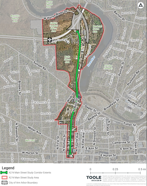
The North Main Transportation Study location will be N. Main Street from Huron Street to W. Huron River Drive.
Potential Design Concepts
Please note the design concepts shown below are not final. These concepts were developed during the charrette process and require further evaluation.
Huron Street
Huron Street Intersection
Concept Summary
The concept creates a more compact intersection that shortens the pedestrian crossings.
- Designing this section as a curbless street improves accessibility and flexibility, particularly for on-street parking and programming. A portion or all of the street can be temporarily closed for festivals, concerts, or outdoor dining.
- Center medians are also included on the south leg of the intersection (South Main Street) and the east leg (Huron Street) where northbound and westbound left turns are not currently allowed and are restricted with yellow cross-hatch striping in the center lane. This will help slow car speeds on these two intersection legs.
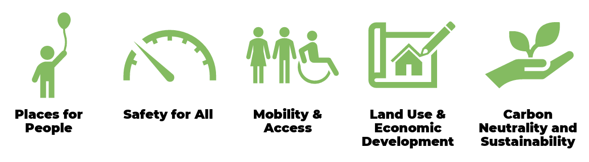
- Design Objectives - Safety for All, Land Use and Economic Development, Mobility and Access
Corridor-Wide
- 4/5-lane to 3-lane road rightsizing.
- Wider sidewalks with a larger buffer from traffic.
- Shared use path from Summit Street intersection to M-14 / Huron River Drive.
- Design Objectives - Safety for All, Mobility and Access, Carbon Neutrality and Sustainability, Land Use and Economic Development
Ann Street
Ann Street Intersection
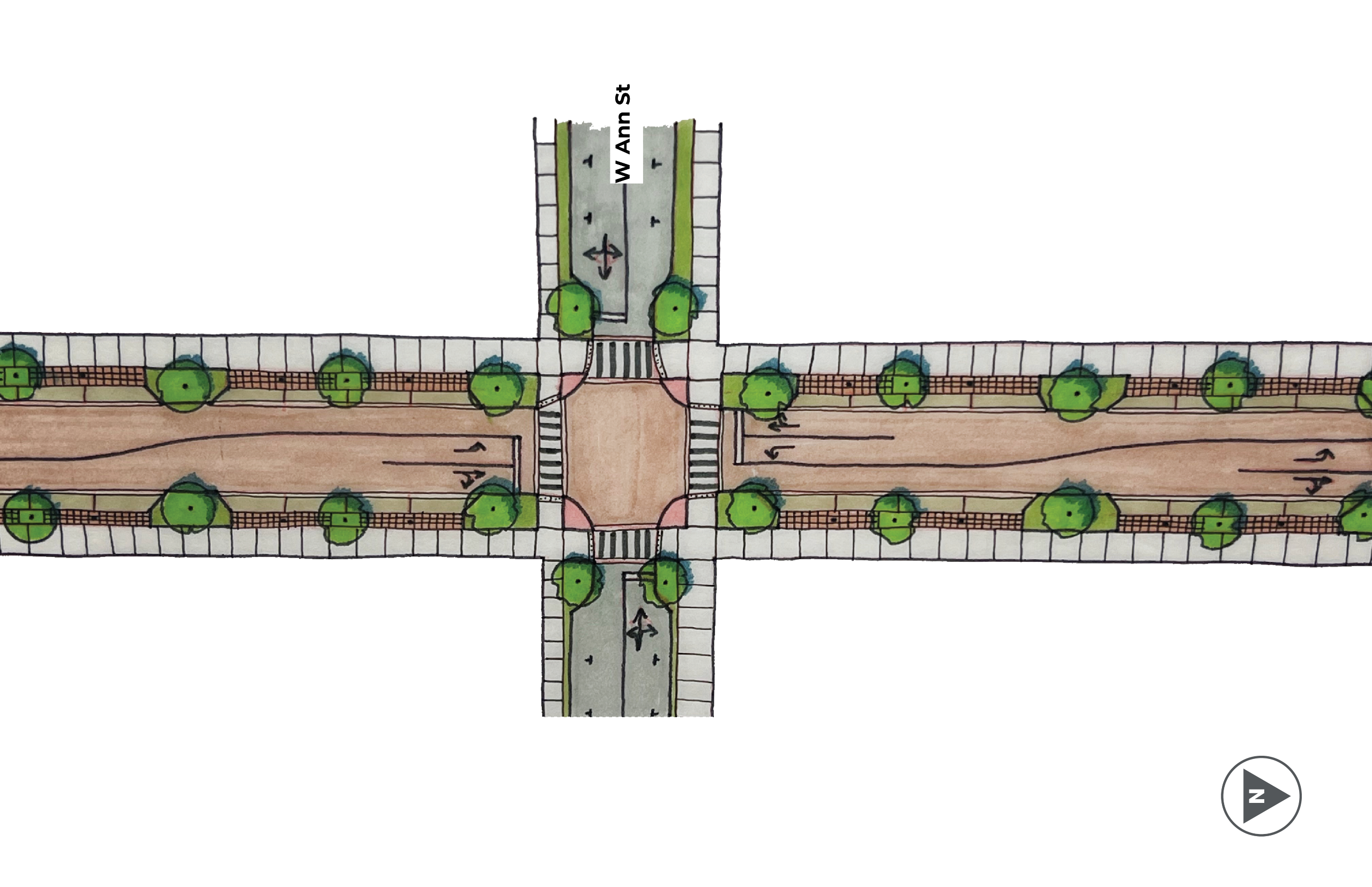
Concept Summary
The concept creates a more compact intersection that shortens the pedestrian crossings.
- Designing this section as a curbless street improves accessibility and flexibility, particularly for on-street parking and programming. A portion or all of the street can be temporarily closed for festivals, concerts, or outdoor dining.
- Design Objectives - Safety for All, Land Use and Economic Development, Mobility and Access
Corridor-Wide
- 4/5-lane to 3-lane road rightsizing.
- Wider sidewalks with a larger buffer from traffic.
- Shared use path from Summit Street intersection to M-14 / Huron River Drive.
- Design Objectives - Safety for All, Mobility and Access, Carbon Neutrality and Sustainability, Land Use and Economic Development
Miller Avenue & Catherine Street
Miller Avenue and Catherine Street Intersection
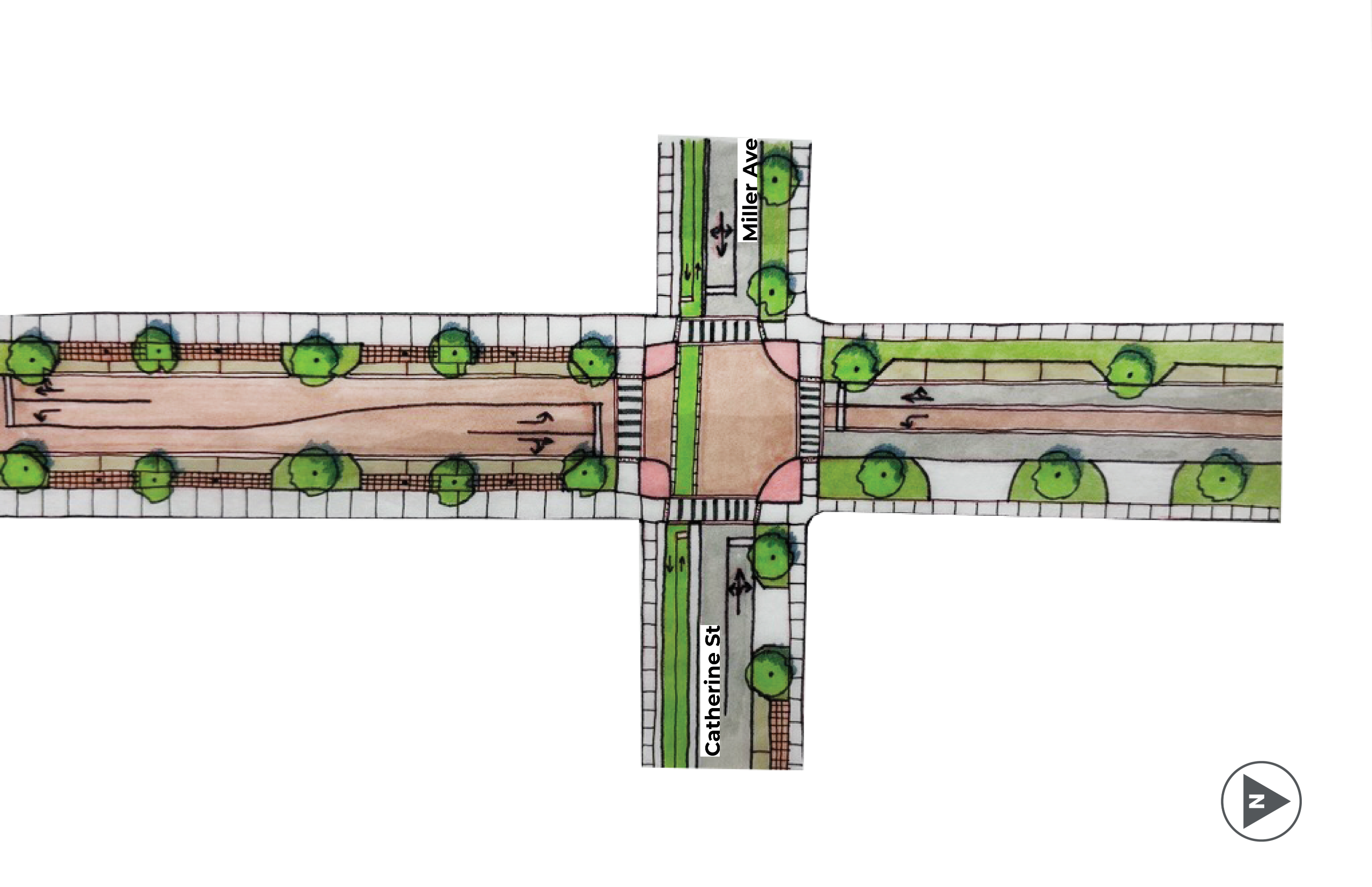
Concept Summary
The two blocks between Miller Avenue/Catherine Street and Huron Street are proposed as a curbless street. This higher-level streetscaping treatment is proposed on these two blocks as an extension of downtown and the existing South Main Street design just south of Huron.
- Designing this section as a curbless street improves accessibility and flexibility, particularly for on-street parking and programming. A portion or all of the street can be temporarily closed for festivals, concerts, or outdoor dining.
- The concept maintains the existing two-way protected bike lane crossing and creates a more compact intersection that shortens the pedestrian and bicyclist crossings.
- Design Objectives - Safety for All, Land Use and Economic Development, Mobility and Access
Corridor-Wide
- 4/5-lane to 3-lane road rightsizing.
- Wider sidewalks with a larger buffer from traffic.
- Shared use path from Summit Street intersection to M-14 / Huron River Drive.
- Design Objectives - Safety for All, Mobility and Access, Carbon Neutrality and Sustainability, Land Use and Economic Development
Kingsley & Beakes Streets
Kingsley Street and Beakes Street Intersection
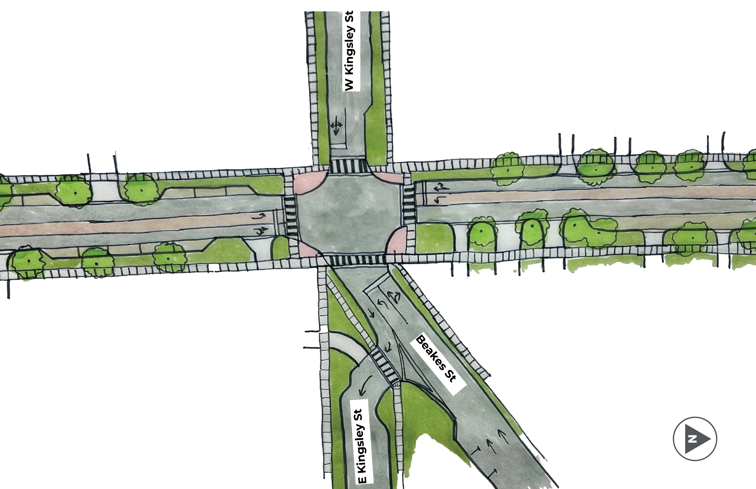
Concept Summary
The concept at the Kingsley/Beakes Street intersection creates a more compact intersection that shortens the pedestrian crossings.
- A curb extension is added on the east side of the intersection at Kingsley Street to slow vehicles turning onto eastbound Kingsley Street from North Main Street.
- Design Objectives - Safety for All, Land Use and Economic Development, Mobility and Access
Corridor-Wide
- 4/5-lane to 3-lane road rightsizing.
- Wider sidewalks with a larger buffer from traffic.
- Shared use path from Summit Street intersection to M-14 / Huron River Drive.
- Design Objectives - Safety for All, Mobility and Access, Carbon Neutrality and Sustainability, Land Use and Economic Development
Felch Street
Felch Street
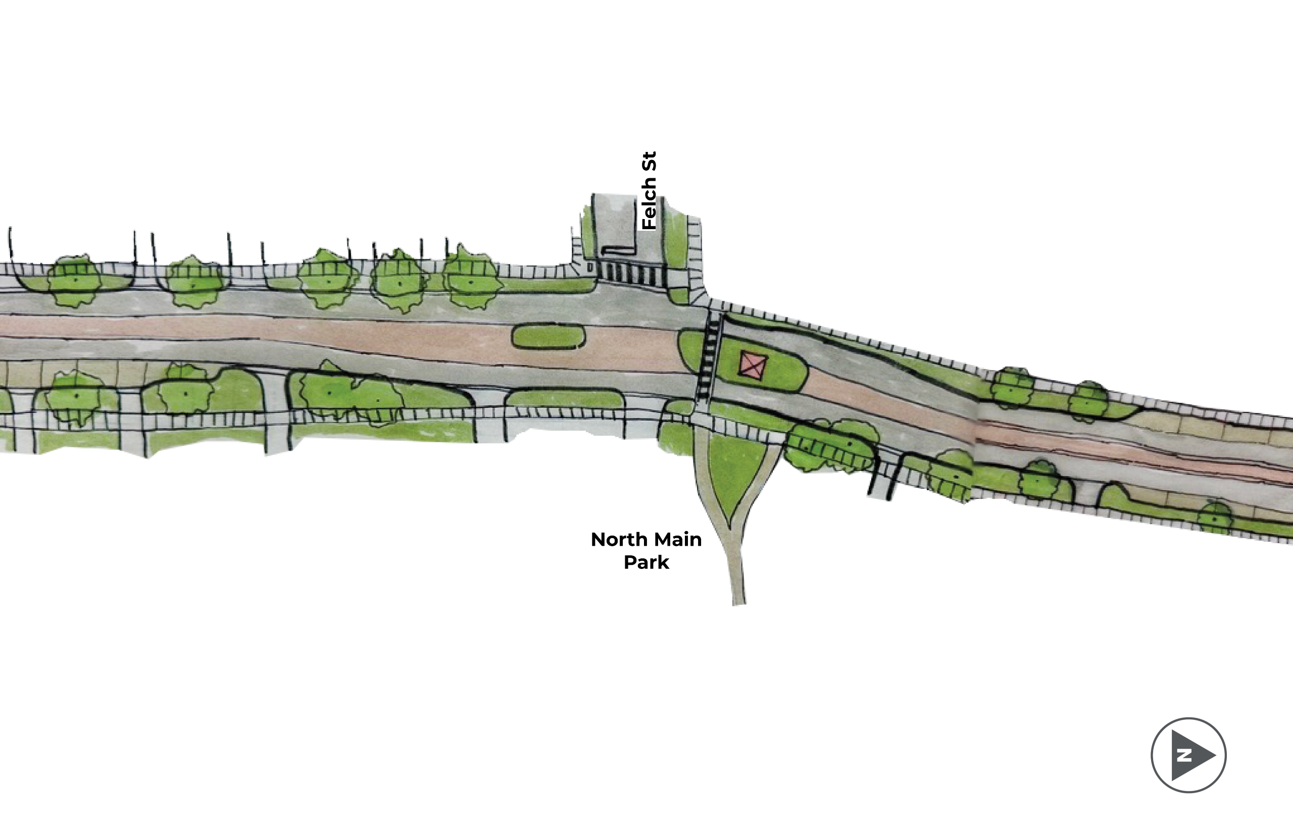
Concept Summary
The concept at Felch Street includes a new enhanced pedestrian crossing at North Main Park and a center median that allows for drivers to make two-stage left turns out of Felch Street onto North Main Street.
- The center median also manages car speeds and can be used for a gateway treatment such as public art or a welcome sign.
- Design Objectives - Safety for All, Land Use and Economic Development, Mobility and Access
Corridor-Wide
- 4/5-lane to 3-lane road rightsizing.
- Wider sidewalks with a larger buffer from traffic.
- Shared use path from Summit Street intersection to M-14 / Huron River Drive.
- Design Objectives - Safety for All, Mobility and Access, Carbon Neutrality and Sustainability, Land Use and Economic Development
Summit & Depot Streets
Summit Street and Depot Street Intersection
Image 1 of 2
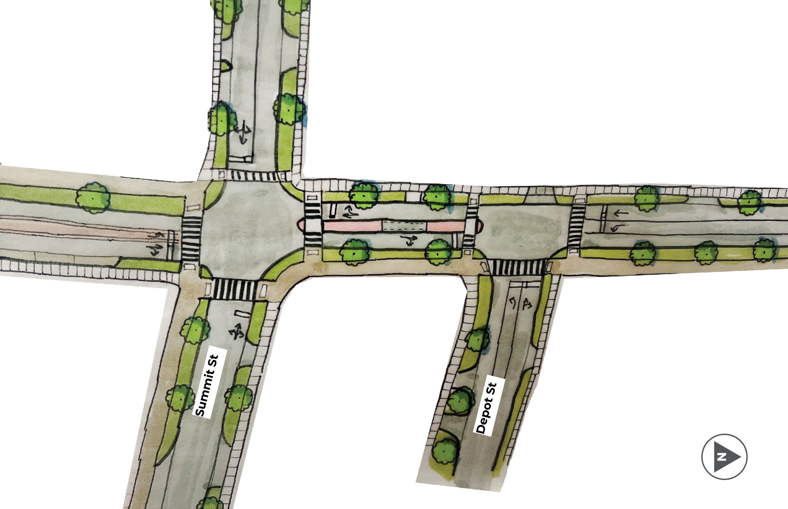
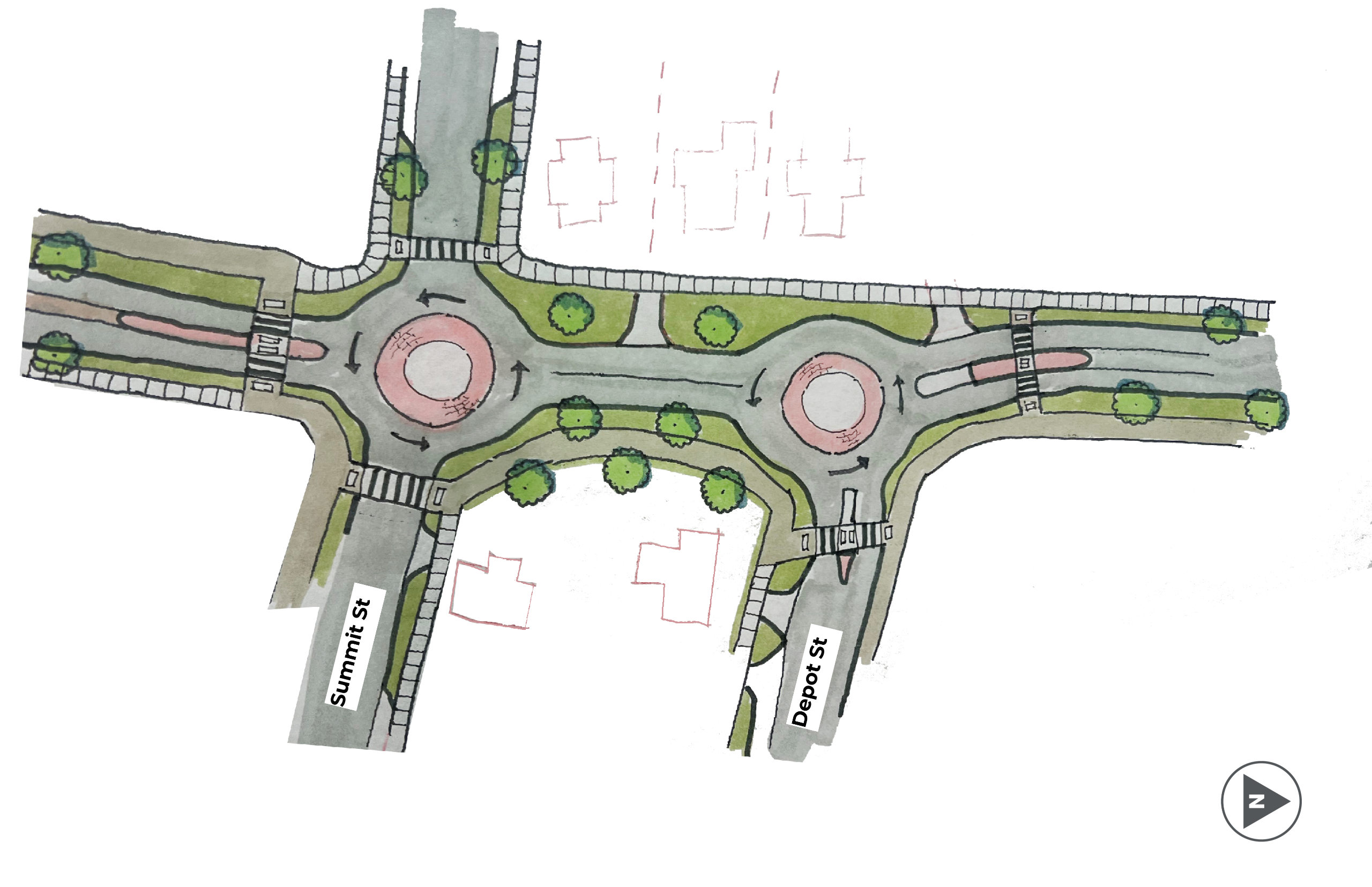
Concept Summary
The Summit Street and Depot Street intersections could include keeping the intersections signalized, with the roadway rightsizing (Option A) or installing compact roundabouts (Option B). The compact roundabouts require minimal easements or purchase of additional right-of-way.
- Keeping the intersections signalized stays within the existing right-of-way and includes a center median between the Summit Street and Depot Street intersections to manage speeds and continue to create a gateway as drivers are entering or exiting downtown.
- Installing compact roundabouts allows for continuous flow of car traffic and slows all vehicles coming into the intersection. The roundabout circles would be fully mountable for the largest semi-trucks to make turns, but all other vehicles (including buses and firetrucks) would travel around the roundabout as they normally would at any other type of roundabout.
- Design Objectives - Safety for All, Land Use and Economic Development, Mobility and Access
Corridor-Wide
- 4/5-lane to 3-lane road rightsizing.
- Wider sidewalks with a larger buffer from traffic.
- Shared use path from Summit Street intersection to M-14 / Huron River Drive.
- Design Objectives - Safety for All, Mobility and Access, Carbon Neutrality and Sustainability, Land Use and Economic Development
Lake Shore Drive
Lake Shore Drive Intersection
Image 1 of 2
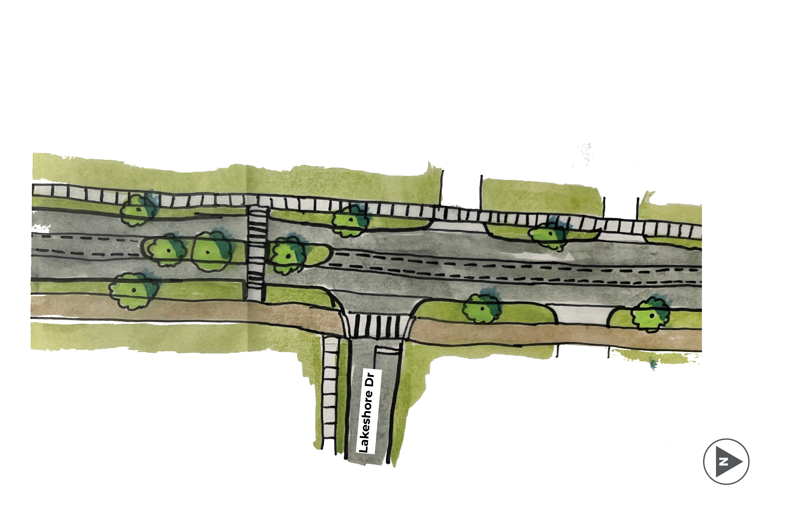
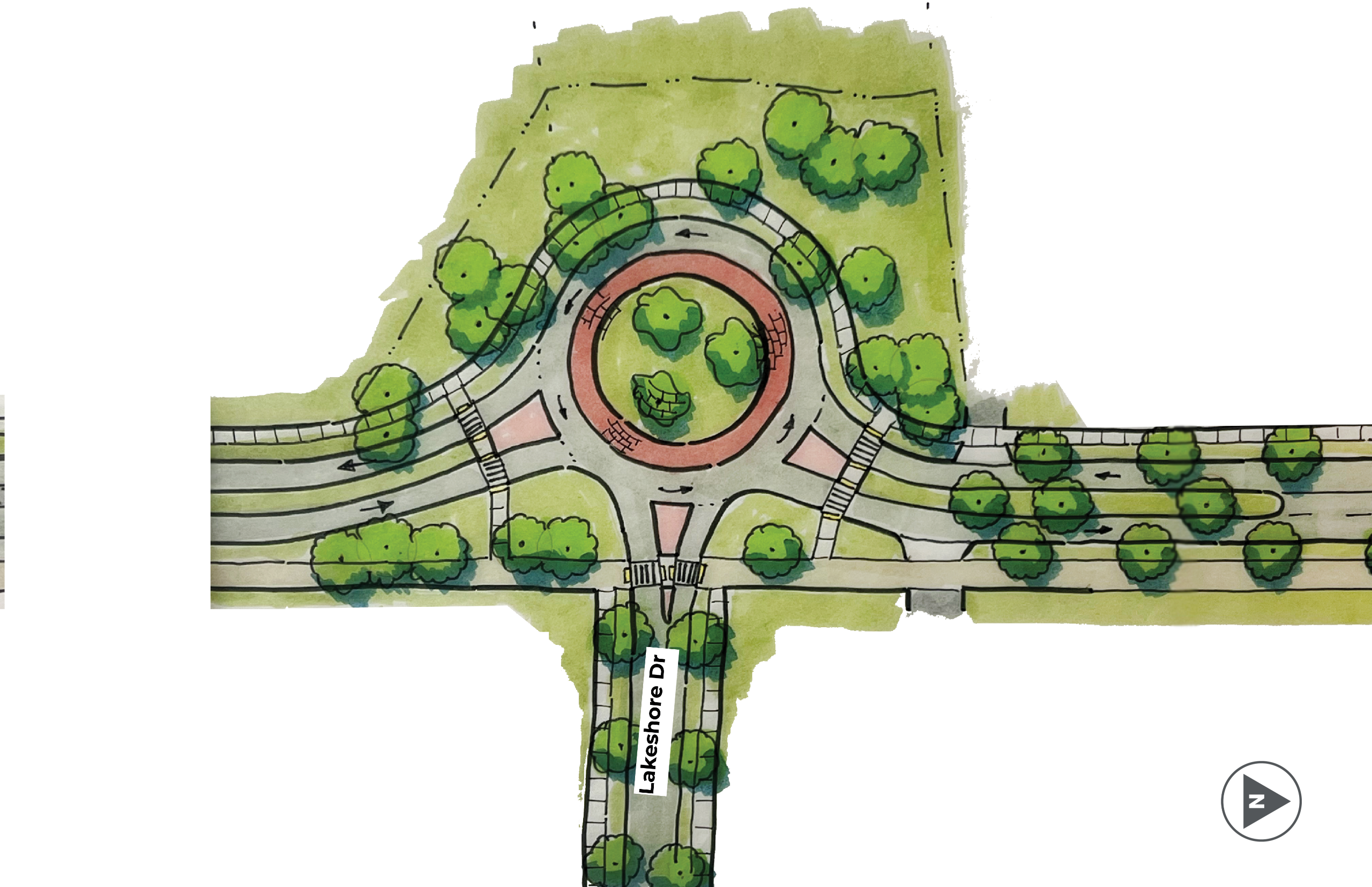
Concept Summary
The Lake Shore Drive intersection could include an enhanced pedestrian/bicyclist crossing or traffic signal (Option A) or a roundabout (Option B). The roundabout requires easements or purchase of additional right-of-way.
- The roundabout adds another speed management feature between Depot Street and the M-14 interchange.
- The roundabout also improves access to Lake Shore Drive and could include an additional access point for the Bluffs Nature Area on the west side of the roundabout.
- The enhanced pedestrian/bicyclist crossing or traffic signal option includes a center median to manage speeds in this location.
- Design Objectives – Safety for All, Land Use and Economic Development, Mobility and Access
Corridor-Wide
- 4/5-lane to 3-lane road rightsizing.
- Wider sidewalks with a larger buffer from traffic.
- Shared use path from Summit Street intersection to M-14 / Huron River Drive.
- Design Objectives - Safety for All, Mobility and Access, Carbon Neutrality and Sustainability, Land Use and Economic Development
M-14 Interchange
M-14 Interchange
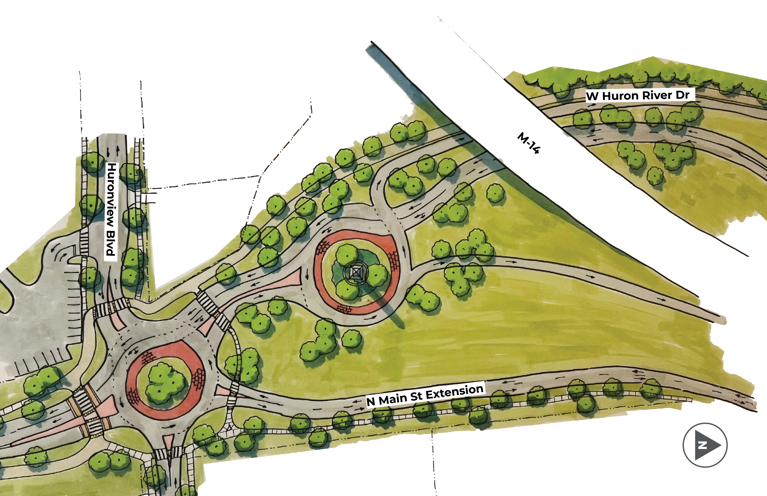
Concept Summary
The concept includes a redesign of the M-14 interchange that includes two roundabouts.
- The goal of this design is to reduce highway driving speeds to city speeds as drivers enter North Main Street.
- The first roundabout is aligned with the existing Huron River Drive intersection. Its purpose is to manage the highway traffic from the north and create a gateway that slows people down as they enter and exit Ann Arbor.
- The second roundabout which is aligned with the existing Huron View Boulevard intersection is a street access roundabout that will make connections and access to properties easier and safer. This roundabout also includes a raised crosswalk on the south leg of the roundabout which is the location with the strongest pedestrian and bicyclist crossing desire today.
- The interchange design concept also includes a new shared-use path on the west side of the street north of the Huron View Boulevard intersection that connects to Huron River Drive.
- Design Objectives – Safety for All, Land Use and Economic Development, Mobility and Access
Corridor-Wide
- 4/5-lane to 3-lane road rightsizing.
- Wider sidewalks with a larger buffer from traffic.
- Shared use path from Summit Street intersection to M-14 / Huron River Drive.
- Design Objectives - Safety for All, Mobility and Access, Carbon Neutrality and Sustainability, Land Use and Economic Development
Public Engagement Summary
Design Week
North Main Street Transportation Study: Community Events
The City of Ann Arbor hosted a series of community events for the North Main Street Transportation Study to gather feedback, share information and work with the public to improve the corridor.
The engagement process occurred in two phases, each featuring a four-day series of events. The Discovery Phase was completed in March, and the Design Phase was completed in May.
- Discovery Phase — March 9–13, 2026: Listened and learned about current conditions, community experiences and early ideas. (Completed)
- Design Phase — May 19–21, 2026: Developed and refined design concepts based on community feedback. (Completed)
Between Discovery and Design weeks the project team explored additional design ideas, evaluated different design concepts against the study's design objectives, and created public materials to highlight the different design concept treatments.
May 19–21, 2026
Community members were invited to attend one or several events to share their input on design concepts for the North Main Street corridor.
All public events took place at the Ann Arbor Downtown Development Authority (DDA) Office in the Kerrytown Market and Shops, 415 N. Fifth Ave., Second Floor.
Open Studio Drop-In Sessions
Tuesday, May 19 | 1–3:30 p.m.
Wednesday, May 20 | 4–6 p.m.
Location: DDA Office, 415 N. Fifth Ave., Second Floor
Community members were invited to stop by to speak directly with the planning team, review materials and provide feedback at a time that fit their schedule.
Public Open House
Thursday, May 21 | 5:30–7:30 p.m.
- Presentation was given at 6:15 p.m.
Location: DDA Office, 415 N. Fifth Ave., Second Floor
Community members could learn about the project and share input on design concepts for North Main Street. Attendees were able to:
- Ask questions of the project team
- Review information about current corridor conditions
- Refine design concepts for the corridor
Discovery Week
North Main Street Transportation Study: Community Events
The City of Ann Arbor will host a series of community events for the North Main Street Transportation Study to gather feedback, share information and work with the public to improve the corridor.
The engagement process occurred in two phases, each featuring a four-day series of events. The Discovery Phase was completed in March, and the Design Phase was completed in May.
- Discovery Phase — March 9–13, 2026: Listened and learned about current conditions, community experiences and early ideas. (Completed)
- Design Phase — May 19–21, 2026: Developed and refined design concepts based on community feedback. (Completed)
Between Discovery and Design weeks the project team explored additional design ideas, evaluated different design concepts against the study's design objectives, and created public materials to highlight the different design concept treatments.
March 9–13, 2026
Community members were invited to attend one or several events to share their experiences traveling along North Main Street.
Most events took place at the Ann Arbor Downtown Development Authority (DDA) Office, 415 N. Fifth Ave., Second Floor.
Public Open House
Tuesday, March 10 | 5:30–7:30 p.m.
Presentation at 6:15 p.m.
Location: DDA Office, 415 N. Fifth Ave., Second Floor
Community members learned about the project and shared ideas for North Main Street. Attendees were able to:
- Ask questions of the project team
- Review information about current corridor conditions
- Share what works well — and what needs improvement
- Help shape priorities for the next phase of the project
Open Studio Drop-In Sessions
Wednesday, March 11 | 2–5 p.m.
Thursday, March 12 | 1–3:30 p.m.
Location: DDA Office, 415 N. Fifth Ave., Second Floor
Community members were invited to stop by to speak directly with the planning team, review materials and provide feedback at a time that worked for them.
- Vision Statement
- "North Main Street will support vibrant and unique community destinations with a safe street where no one is seriously injured or killed."
- Survey Participation
- 451 Respondents
- 100% Completion Rate
- 900+ comments were submitted on the online map.
- For more information, please see the 'Survey Results' tab
- Throughout the week, we held a public meeting and drop-in studio sessions. Small group meetings were also held with business and property owners as well as biking, walking, and disability advocates.
- Some common themes we heard throughout the week are:
- Car speeds are too high
- Access to property is a safety and business viability issue
- Create a more welcoming gateway into the City
- Build better connections to the B2B Trail and parks along the corridor
- Improve sidewalk and crossing infrastructure
- Some common themes we heard throughout the week are:
- Next Steps
- Design Charrette: May 18-21
- Present preferred concept
- Engage stakeholders and community
- Gather input to evaluate options
- Design Charrette: May 18-21
Discovery Week Survey Results
Corridor Experience
Are you an Ann Arbor resident?
I travel on or along the North Main corridor
How do you typically travel along this corridor?
Are there other ways you would like to travel along this corridor?
Existing Conditions
What do you think is working well along North Main Street today?
What makes it difficult to access destinations along North Main Street?
Safety
How safe do you currently feel traveling along North Main Street?
When do you feel unsafe while traveling along North Main Street?
Mapped Comments
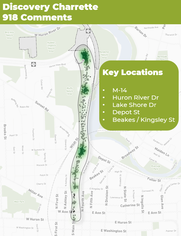 More than 900 comments were submitted on the online map. Key locations for these comments include M-14, Huron River Drive, Lake Shore Drive, Depot Street, and Beakes/Kingsley Street.
These comments fall into several themes:
- Access (82 Comments)
- Bicycle (72 Comments)
- Congestion (59 Comments)
- Crossing (158 Comments)
- Design (73 Comments)
- Operations (104 Comments)
- Pedestrian (80 Comments)
- Safety (110 Comments)
- Speeding (81 Comments)
- Turning (99 Comments)


