
Project Overview
A section of the Border to Border (B2B) Trail between Gallup Park and Geddes Dam is currently closed due to significant deterioration discovered in culverts located beneath the trail embankment.
In July 2026, City staff identified a sinkhole above one of three submerged culverts within the B2B Trail corridor. Subsequent underwater inspections found severe corrosion, separated pipe joints, and active soil loss within portions of the culvert system. Investigations determined that deterioration of the culverts is allowing surrounding soils to migrate into the pipes, creating underground voids beneath the trail.
As these voids develop, they can lead to ground settlement, additional sinkholes, and potential instability of the trail embankment. Based on these findings, engineering consultants recommended closure of the affected trail segment to protect public safety while the extent of the deterioration is fully evaluated and a long-term solution is developed.
The City is currently evaluating repair and replacement alternatives and coordinating with regulatory agencies to identify the most effective approach for restoring the trail connection and ensuring the long-term safety and reliability of this important community asset.
Why is this project being done?
The three culverts provide an important hydraulic connection between South Pond and the Huron River and convey flows from the Malletts Creek and Swift Run Drain systems. Two of the culvert extensions installed by the City in the 1960s have reached the end of their useful service life and are exhibiting significant deterioration.
The project will address these aging structures and provide a long-term solution that restores safety and reliability.
Work to be done
The City is currently evaluating repair and replacement alternatives for the deteriorated culverts. Potential improvements may include:
- Temporary structures to re-open the trail
- Replacement of the failed culvert extensions
- Stabilization of surrounding soils and embankments
Before construction can begin, additional engineering evaluations, permitting, environmental reviews, and coordination with various agencies must be completed.
Because the culverts are located within the Huron River corridor and adjacent to the railroad, the project will require coordination with multiple agencies, which may include:
- Michigan Department of Environment, Great Lakes, and Energy (EGLE)
- Michigan Department of Transportation (MDOT)
- Washtenaw County Water Resources Commissioner (WCWRC)
- Michigan Department of Natural Resources (DNR)
- U.S. Fish and Wildlife Service (USFWS)
The City has initiated the coordination process to identify the most effective path forward while minimizing impacts to natural resources and public infrastructure.
Costs and funding sources
Project costs are currently being evaluated and will depend on the final repair or replacement approach, permitting requirements, environmental mitigation needs, and construction conditions.
Potential funding sources may include a combination of:
- City capital improvement funds
- Parks and Recreation funding
- Stormwater or drainage-related funding sources
- State or federal grant opportunities
- Other funding sources identified during project development
Additional information regarding project costs and funding will be posted as it becomes available.
OCTOBER 5, 2026 UPDATE
Gallup Park B2B Trail – Work Beginning This Week
The City of Ann Arbor will begin work mid-week to stabilize the closed section of the Border to Border Trail in Gallup Park between the Fishing Pond and Geddes Dam.
The trail was closed after concerns were identified with the culverts beneath this section of trail. Since then, the City and its engineering team have been evaluating the options to safely restore trail access. This week, crews will install an interim stabilization measure designed to safely support the trail and allow it to reopen while the City continues evaluating the culverts and planning for a permanent repair. Work is expected to take several days, and the City anticipates reopening the trail before the weekend, weather and field conditions permitting. The trail will remain closed through the work area until construction is complete.
Trail users are asked to continue to stay off the closed section until it is officially reopened. Keeping the work area clear is important for public and worker safety and will allow crews to complete the stabilization work as efficiently as possible so the trail can reopen as soon as possible.
We appreciate the community’s patience and cooperation while we work to safely restore this important trail connection. Updates on the longer-term repair will be shared as plans are developed.
-----------------------------------
SEPTEMBER 29, 2026 UPDATE
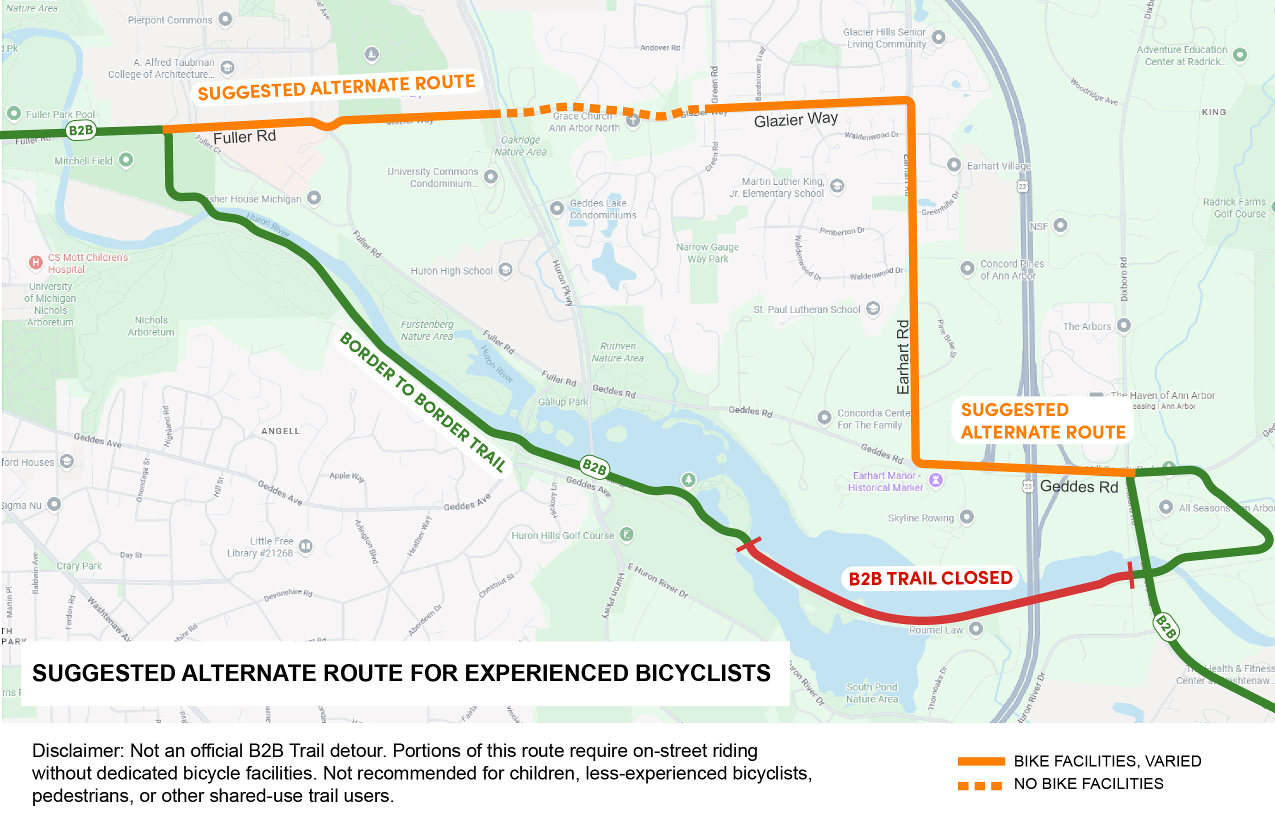
Suggested Alternate Route for Bicyclists
The Border to Border Trail remains closed in Gallup Park between the Fishing Pond and Geddes Dam while repairs are completed. Because there is not a continuous off-street or shared-use path available around the closure, the City is unable to provide a comparable detour for all B2B Trail users. Pedestrians and other trail users should not attempt to travel through the closed section.
For experienced bicyclists who are comfortable riding on streets, the City is sharing a suggested alternate bicycle route around the closure. Portions of this route require on-street riding where dedicated bicycle facilities are not available, so it is not an equivalent replacement for the B2B Trail and may not be appropriate for all riders.
Please keep in mind:
- This is a suggested bicycle route, not an official B2B Trail detour.
- Portions of the route require riding on streets without dedicated bicycle facilities.
- The route is intended for experienced bicyclists who are comfortable with on-street riding and is not recommended for children or less-experienced riders.
- The route does not provide an alternate connection for pedestrians, wheelchair users, or other shared-use trail users.
- Please use caution, follow all traffic laws and posted signage, and choose a route appropriate for your individual comfort and ability.
Please refer to the map below for the suggested bicycle route and the location of the B2B Trail closure.
We appreciate everyone's patience while this section of trail remains closed and work is underway to restore a safe connection.
------------
The City will continue to provide updates as additional information becomes available. Project milestones, schedule updates, funding information, and construction notifications will be posted on this website throughout the life of the project.
Protecting public safety while restoring this important regional trail connection remains the City's highest priority.
The closure affects the Border to Border Trail segment between Gallup Park and Geddes Dam.
Impacts include:
- Temporary loss of access through the affected section.
- Disruption to walking, running, and bicycling routes.
- Reduced connectivity along the Border to Border Trail corridor.
- Longer travel distances to reach destinations on either side of the closure.
A suggested alternative route for bicyclists has been provided; however, at this time, no official trail detour is available that fully replicates the existing route. Users are encouraged to plan alternate travel routes and allow additional travel time.
Project Boundaries
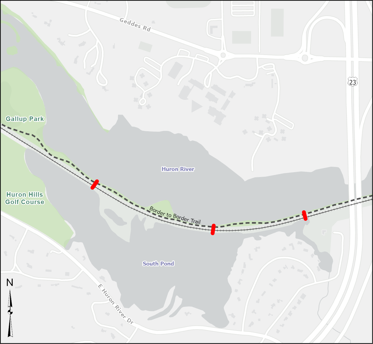
Gallup Park Border to Border Trail Culvert project extent
Alternative Route for Bicyclists
Gallup Park Border to Border Trail Culvert: Suggested Alternative Route for Bicyclists


